Main characteristics
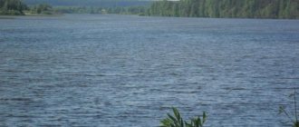
The Vyatka River on a physical map looks like a mirrored question mark. Its length is 1314 km, and the distance between the mouth and the source in a straight line is 300 km. The catchment area is 129,000 km². The riverbed divides it almost in half: 61,000 km² on the left bank, 68,000 km² on the right bank.
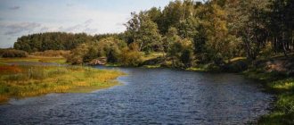
The river meanders and abruptly changes direction. The tortuosity coefficient of Vyatka is 4.15, while on average it rarely exceeds 2.5. During the flood period, a powerful stream often washes a new path, as evidenced by oxbow lakes that have separated from the riverbed and become lakes.
The Vyatka Valley is spacious, up to 20 km, and in the upper reaches it is very swampy. It was formed under the influence of melting glaciers. The water sank into the lowlands and swamps formed. Where the river crosses the Vyatsky Uval, the valley either narrows to 750 m or widens to 4 km.
In the upper reaches, the width of the channel is 40-50 m, the depth of the reaches is from 3 to 5 m, on the rifts - up to 0.3 m. The banks are low, the right bank is slightly higher than the left.
The river valley in the lower reaches ranges from 1 to 5 km. The width of the water flow closer to the mouth reaches 450 m. The depth of the reaches is 7–10 m, on the rifts – up to 0.55 m.
The soil at the bottom is sandy, loose, the stream actively transports it, the underwater topography is constantly changing, numerous riffles, shoals and islands are formed.
The difference in elevation between the source and the mouth is 220 m. Full-flowing and leisurely, the Vyatka is a typical flat river with an average slope of 0.00014.
The average water flow at the mouth is 890 m³/s. Maximum – 9690 m³/s. The minimum in winter is 91 m³/s.
During high water, the current speed is 1.5 m/s, during low water it is 0.5 m/s.
Bystrica River
By?stritsa is a river in the European part of Russia, in the Kirov region; left tributary of the river Vyatki (Volga basin).
The river originates from the village. Verkhobystritsa on the hilly Vyatsky Uval hill near the watershed between the Volga and Northern Dvina basins. The length of the river is 166 km, the basin area is 3740 km 2. Main tributaries: Right Shyam (right); Kyrmyzhka, Bolshaya Kurmena, Ivkina, Snigirevka (left). Swampiness of the basin is 1%, lake content is less than 1%, forest cover is 40%.
In the upper reaches, the river flow is regulated by a reservoir near the village. Krasnooktyabrsky. The river slope varies from 0.56‰ in the upper reaches to 0.73‰ in the average and to 0.15‰ in the lower reaches. The river bed is winding (free bends predominate), mostly wide-floodplain. The banks of the river are easily eroded. The height of the eroded banks is 3–8 m. The width of the channel in the upper reaches varies from several meters to 20 m in the zone of backwater from the reservoir. Below the reservoir dam, the channel width is 20 m, the depth is up to 2 m, the flow speed is 0.1 m/s, the bottom is sandy. In the middle reaches, the width of the channel is from 12 m to 60 m, the depth on the rifts is 0.8 m, on the reaches up to 5.7 m, the current speed is 0.1–0.3 m/s, there are boulders in the channel. In the lower reaches, the width of the channel is 30–80 m, the average depth is 1 m, the current speed is 0.5 m/s, the bottom is predominantly sandy. In the upper reaches, the width of the floodplain is from 20 m to 250 m, below the reservoir – up to 300–500 m. In the middle reaches, the width of the floodplain is from 100 m to 700 m, in the lower reaches – up to 1.5–2.2 km. Along the entire length of the river, the floodplain is covered with meadow vegetation (shrubs along the riverbed) and is swampy in places. In the middle and lower reaches of the floodplain there are many oxbow lakes and reclamation canals.
The river is fed predominantly by snow. The average long-term water flow 37 km from the mouth is 24.7 m 3 /s (flow volume 0.780 km 3 /year). The share of spring floods accounts for about 65% of the annual water flow, summer-autumn low water - 25%, and winter - 10%. The flood begins in mid-April and ends in mid-May; its duration is about 33 days. The average of the maximum water flows of the spring flood is 430 m 3 /s, the highest is 908 m 3 /s. Rain floods during the summer-autumn low-water period can last up to eight days; the highest water flow during floods is 598 m 3 /s. The lowest water flow in summer low water is about 7.92 m 3 /s, in winter low water – 7.03 m 3 /s. The average range of seasonal fluctuations in water level is 430 cm, the maximum is 535 cm.
Ice appears on the river in early November. The autumn ice drift lasts about six days. The duration of freeze-up is on average 160 days. In the second or third decade of March, the ice reaches its maximum thickness (about 58 cm). Spring ice drift begins in the second ten days of April and lasts an average of five days. The total duration of the period with ice phenomena is about 172 days.
The river is home to pike, chub, gudgeon, and roach. There are many settlements on the banks of the river; the largest villages are Strizhi, Rechnoy, Krasnooktyabrsky, Torfyanoy and Bystritsa. The river is crossed by three highways P167, P168 and P169.
Nutrition and regimen
Melting snow is the main source of food for Vyatka. A significant part of the influx in summer and autumn comes from heavy rains. The river is replenished by springs and swamps.
The waters of Vyatka are under ice for almost six months. The river freezes in early November and opens in mid-April.
The flood lasts two months: from the beginning of April to the end of May, sometimes until June. During this time, more than 80% of the total annual flow passes. The water level rises by 4-6 m. This is enough to flood a vast, sometimes swampy floodplain. The maximum rise in water level was recorded in 1979, it was 635 cm. The minimum occurred in 2002 - 542 cm.
During the low-water period, if the summer is dry, the river shallows up to half a meter on the rifts, and up to a meter in the lower reaches. Due to rain, the water level rises again.
The water in Vyatka is soft and muddy. It is used for the needs of settlements. Despite the abundance of industrial enterprises, the river is considered moderately polluted, and closer to the mouth it is clean.
Current direction
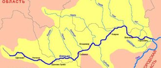
The flow begins its path in the northern part of Udmurtia, on the Verkhnekamsk Upland, at approximately 240 m above sea level. At the source there is a wooden shield and figures of animals and fairy-tale spirits - totems guarding the spring.
Approximately 10 km of the river. Vyatka is moving to the southeast. On the border of Udmurtia and the Kirov region, the channel smoothly turns to the north. Further about a hundred kilometers, the Vyatka moves parallel to another large river - the Kama. After the confluence of the Bolshoi Kirs, the Vyatka turns west.
For approximately 50 km the river remains in a westerly direction. Then it smoothly deviates to the southwest, so that at the confluence of the Solonaya River it turns to the northwest.
Right there, beyond the mouth of the Kobra tributary, near the village of Nagorsk, Vyatka again turns to the southwest. Despite the frequent and sharp bends of the channel, this direction is considered the main direction before the confluence of the Moloma.
From the city of Kotelnich the river moves south, then southwest.
Vyatka crosses the border of Tatarstan near the mouth of Ulyushka.
17 km below the city of Mamadysh the river meets the Kama, and after another 100 kilometers it meets the Volga.
We recommend reading: The largest river systems of Eurasia, rivers of internal flow, length table
Reservoirs of the Kirov region and Kirov
Map of rivers of the Kirov region
Kirov region
has significant water resources; in the region there are 19,753 rivers with a total length of 66.6 thousand km. Most of the watercourses in the region are represented by streams and small rivers, and large rivers by their headwaters. The main water artery of the region is the river. Vyatka with a total length of 1314 km. The largest tributaries of the Vyatka: on the right - Belaya, Kobra, Letka, Velikaya, Moloma, Pizhma, Shoshma; on the left - Cheptsa, Bystritsa, Voya, Kilmez.
Large rivers flowing within the region are also Luza, Yug, Vetluga, Bolshaya Kokshaga, Nemda, Yaran, etc.
The total number of lakes in the region is 4.5 thousand. Together with ponds, the total number of enclosed reservoirs in the region is more than 5.0 thousand. The largest lakes are: Akshuben - 85 hectares, Orlovskoye - 63 hectares, Muserskoye - 32 hectares. The deepest body of water in the region is Lake Lezhninskoye - 36.6 m deep. In the Urzhum region there is a unique lake Shaitan. There are 3 large reservoirs in the region: Belokholunitskoye, Omutninskoye, Bolshoye Kirsinskoye and about 700 small reservoirs and ponds.
Tributaries
85 tributaries flow into the Vyatka River.
Four large rivers join on the left.
Cheptsa - the longest tributary
– stretches for 501 km. It merges with the Vyatka near the city of Kirovo-Chepetsk at a distance of 738 km from the mouth. Winding, full-flowing, calm (slope 0.1 m/km), Cheptsa is popular among rafting enthusiasts. It is fed by melting snow and about 60 tributaries.
Below the confluence of the Loza River on the banks of the Cheptsa, the ruins of the Oktyabrskaya hydroelectric power station, which supplied electricity to the surrounding settlements and collective farms, have been preserved. It was built by local workers, using almost no equipment. Later, when more economical sources of electricity became available, the station was closed. Its ruins have become a tourist attraction, popular with kayakers and fishermen.
Tributary – Kilmez.
It joins Vyatka 222 km from the mouth. The Kilmez is fed by about 30 tributaries. This flat river, 270 km long, flows between the gently sloping right and high hilly left banks, which are covered with dense coniferous and mixed forests. The water is clean and there are a lot of fish in it.
Rivers Voya and Bystritsa
(with emphasis on the first syllable) calm in character. The length of the rivers is 174 and 166 km.
On the right, eight large rivers flow into Vyatka.
Moloma is the second longest tributary.
It stretches for 419 km. It flows from the northwestern edge of the Kirov region to the southeast to the city of Kotelnich. For the first few kilometers the riverbed is so narrow that the trees growing along the banks touch each other with their crowns. Then it gradually expands to 200 m.
There are almost no settlements on Molom, but mills are still preserved, and in some places there are yazs - dams for fishing. Closer to the mouth, a dam was built - a floating engineering structure that is used for timber rafting.
Seven kilometers from the river mouth are the Shabalinskoye and Kovrovskoye settlements. Scientists date these architectural monuments to the XIV-XVII centuries.
Cobra River
The name was not given in honor of a poisonous snake, although the winding channel 324 km long may give rise to such associations. In the Old Russian language, the word “cobra” meant “hands folded into a fistful”, and “to shave” meant “to hide, to live separately, unsociable.” It is believed that the name came from an island located at the confluence of two branches, which is difficult to reach.
The next largest right tributary is Pizhma
305 km long. Traces of ancient burials were found on its banks - the Emanavesky and Pokstinsky burial grounds, which date back to the 12th - 14th centuries.
Previously, the river was navigable, but now it has become so shallow that even small vessels are prohibited from passing through it. The exception is water transport owned by government agencies. However, this fact does not prevent kayakers from rafting along the Pizhma. Tourists are not embarrassed by the difficulties of the route, because the journey by water is approximately equal to the distance that needs to be covered along the shore.
Length of the Letka
is 260 km. It flows into Vyatka 804 km from the mouth. A timber industry enterprise once worked on the banks, and timber was floated on the water.
White Kholunitsa and Velikaya
approximately the same - a little more than 160 km.
Shoshma
105 km long flows through Tatarstan and the Kirov region. It is considered a natural monument of the Republic of Tatarstan.
Buoy
closes the list of major tributaries. Its length is 92 km.
Settlements
People have long settled in the Vyatka basin. Several large cities of the Kirov region are located on the banks of the river:
Ancient city of Slobodskaya
known since the end of the 15th century, although archaeologists claim that it was founded much earlier, in the 13th century. The city's economic heyday came in the 17th century, when the Great Siberian (Moscow) Highway was laid past.
Kirovo-Chepetsk
founded in 1935 on the site of the village of Ust-Chepetskoye, near the Kirov Thermal Power Plant, which was built because rich reserves of peat were discovered around it.
Later, a chemical plant was opened here, which participated in the creation of the atomic bomb. Now the city's hazardous industries are included in the list of potentially hazardous facilities in the region, their work is carefully monitored, and discharges are controlled.
In Kirovo-Chepetsk, folk crafts have been preserved - weaving from willow rods and ribbons.
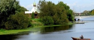
The largest populated area through which the Vyatka River flows is the city of Kirov.
About half a million people live there.
Over the history of its existence, the city was renamed several times. Initially it had the same name as the Vyatka River.
We recommend reading: Chusovaya River: from source to mouth on the map, rafting and fishing
Founded in 1181, Vyatka quickly became a military and commercial center for the surrounding lands. In the middle of the 15th century. A Kremlin was built here, which received the name Khlynov in honor of the Khlynovka River, which flows nearby. The city began to be called the same. The historical name was returned by Catherine II.
In 1934, by decision of the Presidium of the All-Russian Central Executive Committee, Vyatka was renamed Kirov in honor of the murdered revolutionary Sergei Mironovich Kirov. The city still bears this name.
Kirov is famous for the famous Dymkovo clay toy, which is produced in the Dymkovo settlement.
The modest town of Orlov
famous for its regional chess and backgammon tournament.
Kotelnich
included in the list of small historical cities of Russia. It has been known since the end of the 12th century. as the most important trade and transport center. Not far from Kotelnich, ancient settlements that arose in the 2nd century were excavated. BC e. and X–XIII centuries. n. e. Here, on the banks of the Vyatka, the remains of unique vertebrate animals of the Paleozoic era were found: a running lizard, a dicynodont lizard, deltavyatia and vyatkosuchus, named after the river. The exhibits can be viewed at the local museum.
Sovetsk
before the revolution it was called Kukarka. Handicrafts brought fame to the city: beautiful lace that is woven on bobbins, and high-quality felt boots.
Vyatskiye Polyany
until the middle of the 16th century. belonged to the Kazan Khanate and were called Oshtorma-Bodya. Later, the settlement came under the authority of the Vyatka Assumption Monastery.
The industrial city of Sosnovka is located 13 km from Vyatskie Polyany .
There is a legend that the settlement was founded by escaped convicts who liked the quiet corner of nature. The city has a shipyard serving local shipping.
In the valley of the Vyatka River, on the banks of its tributaries, there are still many settlements with a rich history: Kirs, Urzhum, Malmyzh, Kukmor, Nolinsk, Omutninsk and others.
Navigability
Since ancient times, the Vyatka, together with its tributaries, formed an important waterway from the center of Russia to the Urals.
In the 19th century owners of deep-draft vessels were not interested in Vyatka for a long time. Only in 1855 did the first steamship arrive from the Kama.
In 1858, tugboats appeared on Vyatka. This made it possible to open constant traffic along the river. In 1874 they began to transport passengers.
By the beginning of the 20th century. Several shipping companies were already operating, organizing regular flights along the Vyatka, Kama and Volga, including to Moscow and Kazan. In 1902, the owners united the enterprises by organizing the Vyatka-Volga Shipping Company Partnership, which included barges, tugboats and passenger ships of various displacements.
There was no money to deepen the riverbed; the Ministry of Railways paid attention to the development of the railway network, so traveling along Vyatka was inconvenient. To get from one city to another, people transferred from a comfortable American ship to a single-deck one. The ship waited a long time for its turn to pass along the stretches where reverse movement was organized.
In Soviet times, Vyatka was navigable from the city of Slobodskoye. Timber was floated along it and goods were transported: rock salt and grain. Enterprises were built on the coast, the products of which were also transported by water. Despite annual work to clean and deepen the riverbed, gradually deforestation, drainage of swamps and erosion of the banks led to the shallowing of the river. Perestroika and subsequent reforms led to the ruin of factories. Floating timber also became unprofitable. Shipping on Vyatka stopped.
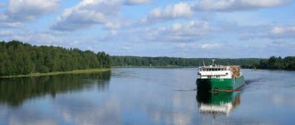
Although the river is not currently in demand as a transport route, it remains navigable. Navigation is possible from April to October. During floods, mainly in spring and autumn, when the depth increases by 3.5-5.5 meters, you can get to the village of Kirs.
Since 2011, in May, during high water, the tourist ship Vasily Chapaev plies along Vyatka. In the capital of the region, boat trips are organized on small boats.
The regional administration plans to resume full navigation and operation of marinas in Slobodskoye, Kirov, Kotelnich, Sovetsk and Vyatskie Polyany.
Silver river Vyatka. Then and now
Read about how settlement took place on the banks of the region’s large water artery and why it ceased to be navigable in our historical blog.
Vyatka is the main river of the Kirov region. Most of the cities in the region are located on its banks: Slobodskoy, Kirovo-Chepetsk, Kirov, Orlov, Kotelnich and others. And if previously the river was navigable and was actively used not only for water intake, now you can see only a couple of small boats and motor ships on it that ply during the navigation period.
This summer, in the Kirov region, the issue of navigation on Vyatka arose again. And already in September, the deepening of the river bed began with the help of the Vyatka district of waterways and navigation. It is still unknown whether these changes will lead to the desired result, so we suggest remembering what Vyatka was like before.
Where did the name come from?
There are three versions of the origin of the name of the river. According to one version, the toponym “Vyatka” appeared from the name of the Udmurt ethnic group “Vatka”. However, in this national language there are no soft sounds, and the stress always falls on the last syllable. Therefore, the river should have been called VatkA.
Another version says that the word “Vyatka” is related to the Old Russian “more”. Probably when the first settlers reached the river along small tributaries and were impressed by its abundance.
The Tatar name of Vyatka – Nokrat – is a distorted “Novgorod”, “Novgorod River”. After all, after the ancient Russian development, it was the Novgorodians who came to live on the banks of the Vyatka. By the way, the derivation of the Tatar name of the river (noqrah - “silver”) is a folk etymology, since the water in the river was almost always clean.
Population and geography
Vyatka originates in the Verkhnekamsk Upland of Udmurtia. Then it flows to the north, turns west, southwest and south, after which it flows into the Kama near the village of Grakhan in the Republic of Tatarstan. Vyatka is characterized by sharp changes in flow direction, so it is quite tortuous. Its length is 1314 kilometers. Vyatka receives its water supply from underground sources, rain and snowmelt.
It is not known for certain when the first person settled on Vyatka. Initially, the Novgorod ushkuiniki settled on the banks of the Vyatka in order to raid the lower reaches of the Volga. Later they were joined by colonial settlers from Novgorod. From the 7th to the 10th centuries the region was inhabited by the Chud, then the Votyaks (Udmurts) came from the east, and by the 13th century the Cheremis (Mari). Russian colonization began only in the second half of the 14th century. The settlements of that time were trade and administrative centers.
Gradually, the river became an important waterway connecting the Middle Volga - the territory of Volga Bulgaria, and later the Kazan Khanate - with the Sukhona-Vychegda river route and the Novgorod lands.
Use of the river
Shipping
At the beginning of the 20th century, the Vyatka found itself in the top ten large rivers of the European part of our country. It became one of the most important trade waterways for today's central Russia, along which grain, timber and rock salt were transported. Dozens of enterprises were built along the banks of the river: Kirsinsky ironworks (1729), Peskovsky iron smelting plant (1771), Match factory (1873), Sawmill (1913), Sosnovsky shipbuilding plant (1924), Kirovo-Chepetsk chemical plant (1939 ) and others. In addition to the materials produced on them, export items included bread, flax, leather goods and furs.
The Vyatchans saw the first steam ship on the river in May 1855, when the 120-horsepower steamship Lyubimy of the Perm merchant Lyubimov came from the Kama. In 1858, the first steamship partnership was organized by Vyatka merchants A. Kuklin, V. Stolbov and Oryol merchant I. Chudinovskikh. The first steamship was the Vyatka, which was intended for towing. After this, regular traffic began on the river.
In 1863, Oryol merchant Philip Bulychev began his shipping business. In April 1871, in Vyatka, he opened a shipping company office, which was then headed by his son, Tikhon. Within three years, Tikhon Bulychev opened passenger service between Vyatka and Kazan with two ships: “F.Bulychev” and “Pochetny”, and by 1900, 21 of his ships were already plying along Vyatka.
At the same time, other shipowners were also engaged in river transportation. One of them is Yakov Tyryshkin, he owned 12 steamships. Since 1870, regular steamship traffic began on Vyatka, and the double-deck passenger steamships “Moscow”, “Bulychev”, as well as the single-deck “Son”, “Grandfather”, “Naslednik” moored at the piers of Kotelnich.
At the beginning of the 20th century, a native of Slobodskoye, Pyotr Alexandrov, appears in Vyatka, he invites Bulychev and Tyryshkin to unite in a partnership. The union took place, and in December 1901, the largest river monopoly on Vyatka was formed - the Volga-Kama-Vyatka Shipping Company Partnership with a capital of 3 million rubles and 36 steamships. True, in 1918, after the decree on the nationalization of the merchant fleet, the property of a large partnership became the national indivisible property of the Soviet Republic.
On this topic
Where do Vyatka ships go?
5286
The Vyatka has always been considered a shallow river, mainly because of its rapids. They are formed due to loose rocks that form the banks and bed of the river. They contribute to the formation of shallows, sandbars and islands that impede navigation in the summer. The average depth of the Vyatka is about 5 meters, but in the upper and lower reaches of the river it can be only 40-85 centimeters. The regional Ministry of Environmental Protection recorded in 2021 that the depth of the river has not changed since the beginning of the 20th century.
Back in 1910, playwright Pyotr Olenin-Volgar wrote “Guide to the Vyatka-Volga Shipping Company,” calling Vyatka a “huge river” and denoting that “shallow water is the enemy of navigation.” It is for this reason that in the summer tourists have to stand aground, wait at the riffles for the passage of caravans, and transfer from ship to ship.
According to Olenin-Volgar, only small American-type steamships could sail in the shallow waters of Vyatka, and the rest plied until the water subsided. By those standards, travel fares were quite low: from Vyatka to Kazan about a thousand kilometers, and the cost of a ticket was only 3.75 - 12.6 rubles. In addition, in the restaurants of the ships one could have a meal on a royal scale. Passengers were provided with hot and cold meals, as well as drinks and desserts for an additional fee.
The shipping company on Vyatka continued to develop, and by 1924, 70 piers appeared on the river, 19 of them were landing stages (floating piers - ed.). In total, 88 ships sailed along Vyatka, 11 of them were passenger ships.
Throughout almost the entire 20th century, the river was the main transport artery of the region. At the end of the 80s, traffic volumes on Vyatka exceeded 1.5 million people. But the reorientation to a market economy in 1990 and the transfer of river shipping into private hands reduced the volume of traffic. In 2003, the Vyatka River Shipping Company was declared bankrupt.
Timber rafting
On this topic
When were the largest wooden rafts on Vyatka?
10195
The navigation period lasts on Vyatka for about 6 months. In spring, the water rises to 3 - 5.5 meters; in July and August the water level drops. In addition to spring floods, there are also autumn ones. Due to rains, water in Vyatka rises by 1 - 2 meters.
Rafting timber after ice drift was always a highlight of the beginning of navigation. There were three types of rafting: mole - logs were rafted in a chaotic manner; raft - rafts were formed from harvested wood and sent along rivers using a tug; koshelny - logs were driven into a special fence and transported by motor ships.
“When we were waiting for big water, the roadsteads were busy with work. Just have time to turn around, you need to send all the rafts, and so that they arrive at the place intact. On the way to its destination, it was very easy to run aground. People were on duty on the rafts around the clock. If the raft touches the shore, then no ropes can pull it out. You need to know Vyatka like the back of your hand, otherwise the raft will be “pulled away” along the way, fleet veterans tell the newspaper “Rechnik Vyatka”.
However, many logs sank, causing environmental damage to the river: shallowing and pollution. In order to prevent further consequences, timber rafting along the Vyatka River was stopped in the 1980s, and rafting - in the early 1990s. Now in the Kirov region it is cheaper to export timber by land.
Fisheries and tourism
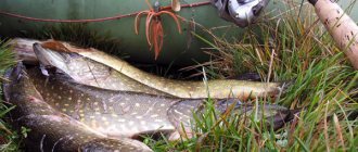
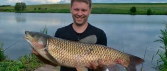
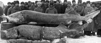
Since ancient times, fishing on Vyatka has been one of the most popular industries. Fishing occurs at any time of the year, but summer and spring are still popular seasons. The river is mainly inhabited by pike, pike perch, burbot, sterlet, sabrefish, ruff and perch. In the upper reaches there are gudgeon, dace, roach, sop, bleak, sculpin and spined loach. Sometimes you come across catfish, carp, podust and bersh. In the middle and upper reaches there are silver crucian carp, goby, and goby. Crayfish live in large numbers in the lower reaches.
In addition, in Vyatka there is the Nurgush nature reserve, founded in 1994, as well as several sanatoriums and resorts - in Sosnovka, Vyatskie Polyany, Russky Turek and others that attract tourists.
On this topic
3865
Toothy trophies and a meeting with armed poachers. Weekly report from fishing in the Kirov region
Vyatka now
Now Vyatka only satisfies household, drinking and industrial needs. But in August 2021, the governor of the Kirov region, Igor Vasiliev, spoke about plans related to clearing the Vyatka riverbed and resuming navigation. To implement the project, the governor expects to attract federal investment. By the way, the last riverbed cleaning work was carried out in 2003.
– I think that we should restore the tradition when ships sailed along Vyatka. Negotiations are now underway with the Russian Ministry of Transport to receive federal funding and begin cleaning the river bed next year,” said Igor Vasiliev.
In 2012, river cruises returned to the area, which had not been seen since the 70s. During the spring flood, the motor ship "Vasily Chapaev" passes through Vyatka, and during the navigation period you can see the small motor ships "Kirovchanka" and "Flagman" near Kirov.
Photo: vyatkawalks.ru, humus.dreamwidth.org, Safronov A.V.
Etymology of the name and history of the river's settlement
The first people appeared on the banks of the Vyatka in ancient times - about 50 thousand years ago. Scientists have found sites from the Mesolithic, Neolithic, Bronze and Iron Ages.
About life in the 7th century. BC e. tell the story of the artifacts found during excavations of the Nagovitsynsky, Pizhemsky, Krivoborsky settlements, attributed to the Ananino culture. In those days, the Tissagets, representatives of the Finno-Ugric tribes, lived here.
We recommend reading: The Velya River flowing in the Moscow region, description, fishing
At the threshold of our era, the ancestors of the Udmurts, Maris and Komi lived along the banks of the river. They settled along the Vyatka valley in the east, west and north, respectively.
Interesting fact. According to the stories of the aborigines, between the houses under the Vyatka River there are walkers dug - underground corridors along which in the past people walked freely to each other without swimming across the river.
It is believed that the name of the river was given by one of the Udmurt tribes. Initially it sounded like Vatka, but later changed. But this version has many opponents who claim that in the languages of the Finno-Ugric group there is no soft “v”, and the stress is traditionally placed on the last syllable. So the word would sound like Vatka.
At the end of the 9th - beginning of the 13th centuries. Russians began to settle on the banks of the river. Their settlements: Orlovskoye, Kotelnichskoye, Khlynovskoye, Kovrovskoye, Nikulitskoye - were located between Kotelnich and Slobodskoye. This fact proves the most harmonious hypothesis of the origin of the name. Adherents of the theory claim that the word “Vyatka” was formed from the Old Russian “vyache”, which means “big”. The name is given in contrast to the Moloma River, which translates as “smaller”. It is believed that after walking along shallow tributaries, the Novgorodians saw a wide river, it was the Vyatka.
Some toponymists believe that the name is consonant with the word “branch” (compare: a tree branch or a branch from something) and has the same root.
Interesting fact. Nokrat is the name given to Vyatka by the Tatars. The name is a corruption of the word "Novgorod". After the Russians developed the banks of the river, it was the Novgorodians who moved here.
Rivers and lakes
The total number of rivers in the region includes more than 1980 reservoirs, the total length of which is about 70 thousand km. All of them are fed from sources that are located both on the surface and inside the soil. They flow smoothly and calmly. The most important river in the region is called Vyatka. Its length is more than 1500 meters. The river can be classified as a typical body of water with considerable tortuosity.
It flows through a valley, is surrounded by rocks and has typical changes in flow direction. In mid-November the river begins to freeze and by the end of the month it is completely covered with ice. The reservoir is rich in waterfowl and various species of fish. Along the banks of the river there are populations and regions: Slobodskaya, Kirovo-Chepetskaya, Kirov, Orlov. One of the most mysterious lakes in the region is Lezhinskoye, which was formed more than 400 years ago.
It appeared as a result of the collapse of deep cavities. The shore of the lake is surrounded by forests, thanks to them the wind does not get here. The depth is about 40 meters and the diameter of the lake is 390 meters. In addition to extensive underwater vegetation, the lake is home to various types of crayfish, pike, and roach. In the Kirov region there is another local reservoir, Shaitan.
If the name is translated from the Tatar language, it means “devil”. Shaitan is located on the border with the Republic of Mari El. Its depth is 20 meters. This lake has a peculiarity: as a result of siphon circulation in the current, a fountain occurs, which reaches a height of 12 meters. This phenomenon is very difficult to capture or film, as it occurs unexpectedly.
Flora and fauna
The nature on the banks of the Vyatka is beautiful and diverse. From the gentle slopes, from the low mountain ranges in which numerous caves have formed, rivers flow and waterfalls rush down. The swamps give way to dense forests: deciduous or pine and fir-spruce, characteristic of the taiga.
Closer to the south, oaks, maples, elms, and lindens appear. The undergrowth consists of bushes of honeysuckle, rose hips, rowan, lilac, buckthorn, juniper, and hazel. The lower level is filled with berries: blueberries, blueberries, lingonberries, cranberries, bearberry. More than 40 species of shrubs and trees are found in the river valley.
Under the arches of the forest live moose, hares, wolves, raccoon dogs, wolverines, lynxes, foxes, martens, wild boars, beavers, squirrels, stoats, minks, ferrets, badgers and bears. Birds include black grouse, cuckoos, woodpeckers, wood grouse, hazel grouse, woodcocks, herons, and gray cranes. Waterfowl nest in large numbers near the water: geese, ducks.
In water meadows you can find up to 1,100 different types of plants. Among them there are endangered species, for example: medicinal and Volga valerian, Siberian iris, oak anemone, clubmoss, reed horsetail, cut incense, nettle-leaved speedwell, pisiform vetch, Gmelin's rank, European swimmer, Siberian bookworm, water lily.
Reindeer listed in the Red Book live in vast expanses similar in characteristics to the taiga. In addition to them, there are 18 more species of endangered animals in the region, including the forest dormouse, Siberian salamander, Russian muskrat, black stork, black and red-breasted goose, eagle owl, golden eagle, bittern, lesser lesser white-fronted goose, lamprey, European grayling and the rarest white-tailed eagle and osprey.
To preserve the nature of the region, more than 200 nature reserves have been organized. One of the most significant - "Nurgush" - is located in the Kotelnichesky district. Its territory of 23.5 hectares includes 50 lakes and 5 rivers, 550 species of plants, 87 species of moss, and about 100 species of algae and lichens grow here. The reserve is home to 50 species of mammals, almost 200 species of birds, 30 species of fish, and 2,430 species of invertebrates.
You can walk around the protected area with a guide. The routes “Reserve Motif” and “On Reserve Paths” are open to tourists.
Plants
Natural vegetation in the Kirov region is very diverse. This mainly happens because more than 55% of the total area is occupied by coniferous and forested plateaus. Which consist of: pines, fir, spruce, aspen, birch, oak, linden and maple. In the southern part of the region you can see a large number of bush plants, such as rowan, rose hips, juniper, lilac. In total, there are about 50 different species of shrubs and trees in the region.
In the forested steppes you can see various berry plants: blueberries, currants. Lingonberries, blueberries. In the southern part of the region you can find trees on which nuts grow. The region's vegetation includes 900 different species of flowers and herbs, some of which are listed in the Red Book. Such representatives of the flora include: nettle-leaved speedwell, pea-shaped vetch, Gmelin's rank, cut incense, reed horsetail, medicinal valerian, Siberian iris and many others.
While walking through the forests, you should pay attention to the large number of different types of mushrooms, these include: porcini mushrooms, aspen mushrooms, saffron milk caps and others. Numerous types of grasses grow near rivers, including: field fescue, foxtail, white bentgrass, awnless brome, and creeping wheatgrass. In the reserves there are plants that are under strict protection, including: tree-like junipers, Siberian scribe, helmeted orchis, wood anemone, clubmoss, European swimmer, water lily.
Rafting and fishing
Vyatka supplies water to nearby settlements, it provides industrial and agricultural enterprises. Despite the pollution with harmful chemicals and shallowing, it attracts many vacationers.
Nature lovers travel with tents, go boating and kayaking, explore the shores, caves, grottoes, admire dense forests, and breathe in the aroma of herbs.
The river is full of fish. Fishermen catch pike, pike perch, sterlet, silver bream, bream, perch, crucian carp, burbot, saberfish, and ruffe. Where the source of the Vyatka River is located, there are roach, dace, sopa, gudgeon, spike, sculpin, bleak, catfish, podust, bersh, carp. Below - goby, silver crucian carp, quicksand. Closer to the mouth there are many crayfish. The river valley is rich in small lakes and oxbow lakes, where rudd, loach, verkhovka, golden carp, minnow, carp, peled, silver carp and grass carp are found.