General information about the Bratsk Reservoir
The Bratsk Reservoir is an artificial reservoir in the Bratsk district of the Irkutsk region, formed on the Angara after the construction of the second stage of the Angara cascade. The Bratsk Reservoir is considered the second largest reservoir in the world in terms of volume of accumulated water and one of the largest in area - its length reaches 570 kilometers, its width is almost 25 kilometers. The average depth of the reservoir is 31 meters, while the maximum depth at the dam itself reaches more than 100 meters. The reservoir has a unique coastline - along its entire length it is indented with small winding bays. The largest bays of the reservoir formed at the confluence of the Angara, Iya and Oka rivers.
Bratsk Reservoir
113 km from Irkutsk, after Bolshoy Island and the Narym Channel, approximately opposite the mouth of the Belaya - the third major tributary of the Angara - the backwater of the Bratsk Reservoir begins to be clearly felt. It was formed during the creation of the Bratsk hydroelectric power station and is the second stage of the Angarsk cascade. Filling to the design level occurred from 1961 to 1967. Carrying out deep long-term regulation of the flow of the Angara, the Bratsk Reservoir in terms of its volume - about 170 cubic km - is the largest artificial reservoir in Russia and the world (among the river-bed reservoirs); only one African reservoir, Victoria (Owen Falls), created on the basis of a huge lake, exceeds the Bratsk reservoir in volume. The water surface area of the Bratsk Reservoir is 5470 sq. km, the useful volume is over 48 cubic km, the length (along the Angara valley) is more than 500 km, the maximum depth at the dam is 106 m.
When traveling by boat, the length of the waterway will inevitably be greater than the length of the reservoir due to approaches to piers and moorings, entries into bays, etc. The entire route from the Irkutsk river station to Bratsk therefore increases from 606 km along the direct transit route to 660 km actual.
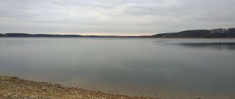
Almost along its entire length, the Bratsk Reservoir has a general orientation to the north along the former Angara, and in the zone where the backwater wedges out (approximately to Svirsk) the reservoir is still barely distinguishable from the river. Its width here ranges from 1 to 4 km, the average depth is 8 m, the water temperature does not exceed 12-14 degrees. Down from the mouth of the Belaya, steppe and forest-steppe developed by agriculture stretches along the banks. The banks are steep, and ancient limestone rocks are visible on them in the form of horizontal and inclined layers, painted in light and gray tones.
On the right bank, opposite the mouth of the Belaya, is the picturesque village of Olonki, where the first Decembrist V. Raevsky lived in a settlement for many years. Further, along the same bank, you can see the village of Buret, famous for the rich Upper Paleolithic site discovered here. On the left bank there is the Barkhatovskaya timber transshipment base.
After 139 km of waterway from Irkutsk, the ship arrives at the port of the small satellite town of Cheremkhovo - Svirsk (19.5 thousand people), connected to it by railway and highway. Svirsk was born in the production of accumulators, galvanic cells and batteries, which went into operation in 1940, and was given city status in 1949. There is a ferry crossing here.
Beyond Svirsk, the railway departs from the reservoir to the west. Cities and towns are left behind, the landscape becomes exclusively rural.
12 km from Svirsk, on the right bank at the mouth of the Ida, is the ancient village of Kamenka, founded back in 1669 as a certain fort. Now the place where the fort stood is flooded by a reservoir.
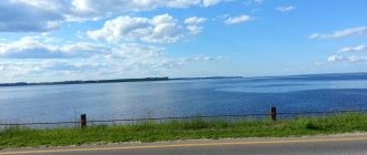
Below the mouth of the Ida, the lands of the Ust-Orda Buryat National District occupy not only the right, but also the left bank of the reservoir, which crosses here the central area of the historical settlement of the Baikal (western) Buryats. Approximately 195 km from Irkutsk, the Bratsk Reservoir expands to 7-12 km and takes on a marine appearance. At 40-45 km the bays cut into the land: Osinsky on the right and Unginsky on the left. Average depths increase to 20 m, maximum temperature - up to 19-20 degrees (even higher in bays).
Along the banks of the Bratsk Reservoir, karst phenomena are observed - failures and subsidence, karst sinkholes and niches, landslides and subsidence of slopes, disappearing streams, etc. With the creation of the reservoir, karst processes characteristic of this area sharply intensified in the coastal zone. The Bratsk Reservoir is also characterized by intense processes of bank destruction associated with large amplitude of water level fluctuations. Usually they do not exceed 2-3 m, but in dry years they increase to 5-6 m, and in critical periods - up to 10 m. The length of the destroyed banks exceeds 2 thousand km or more than a third of the entire coastline of the reservoir, and the total area of erosion was over 5 thousand hectares.
Below the Osinsky and Unginsky bays is the border of the Ust-Orda district, the left bank is further occupied by the lands of the Balagansky district, and the right bank is occupied by the Ust-Udinsky district. The regional center - the village of Balagansk (4.2 thousand people) is located on the left bank, 262 km of the waterway from Irkutsk. Balagansky fort, founded in 1654, was repeatedly sieged by Buryat and Mongol troops, and in 1775 it was elevated to the rank of
cities. After the filling of the Bratsk reservoir, Balagansk was placed in a new location, 35 km from the old settlement, and practically nothing remained from the former city except the memory of the glorious past. Nowadays it is famous for its fish factory, which produces fish from the reservoir and processes it; the ancient Shelashnikovsky highway passes through Balagansk, connecting Zalari on the Trans-Siberian Railway with Zhigalovo on the Lena; There is a ferry service. Interesting karst caves were discovered near the village, and fossil marine arthropods - trilobites - were found in the limestone on the steep banks.
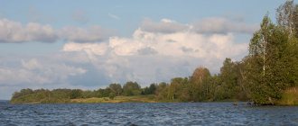
Below Balagansk, for 150 km, the banks of the reservoir are steep and steep, colored red and red-brown due to the predominance of clayey rocks. 20 km from Balagansk, on the opposite bank, stands the village of Ust-Uda, the center of the district of the same name. Beyond Ust-Uda, the reservoir enters the taiga zone. The shores and coastal hilly areas are exceptionally picturesque, the water is warm, so the area is of great interest for summer recreation.
After the large right-bank Udinsky Bay, the reservoir sharply narrows to 2-2.5 km and for 200 km north to Shumilovo repeats the smooth bends of the Angara. However, the depths here are large: the average is 40 m, the maximum is 75 m. The ship passes logging villages with piers - Klyuchi, Anoso-vo, Atalanka, Karda, Podvolochnoe, Chisty, Karakhun, Priboyny, Yuzhny. All of them were built after the creation of the Bratsk Reservoir, which flooded old villages (the native village of the writer V. Rasputin also remained under water). From here, rafts with timber harvested in the territories adjacent to the reservoir go north to Bratsk and, partially, south to Svirsk and Usol-Sibirsky. From Podvolochnoye there is an old road (volok) to Ilim, from Karahun a new road has been built to the Okinsky shore of the reservoir.
From Shumilovo (524 km from Irkutsk) the expansion of the Bratsk reservoir begins again. The shores here are very rugged. The narrow bays look like fiords up to 40 km long. The ship approaches Zayarsk, located 562 km from Irkutsk and 98 km from Bratsk. This village is the successor of the flooded Zayarsk, created in the late 30s as a pier, transshipment point and the beginning of the road from the Angara to the Lena to the Ust-Kut region.
From Zayarsk the ship turns west and heads towards Bratsk. The reservoir becomes especially wide - up to 12-15 km, and the maximum depths reach 95 m. From the right bank, a characteristic cape with Mount Monastyrskaya protrudes far into the sea, where the reservoir is divided into two large reaches: the main Angara and Okinsky-Iysky, approaching Bratsk from South. Maximum depths reach 106 and even 150 m, the width of sections of the Oka part is 20-25 km, the highest wave height during storms exceeds 3.5 m. The length of the Oka branch of the reservoir is 320 km, the Iisk branch that branches off from it is 180 km.
660 km of the waterway from Irkutsk is the Bratsk port - the final point of the Meteor movement, from where the acquaintance with the legendary Bratsk begins - a living example of the enthusiasm and romance of the conquerors of Siberia in the 50s and 60s. Bratsk, founded as a fort at the mouth of the Oka near the Padun rapids in 1631, was burned more than once by warlike Buryat tribes, moved and rebuilt. The first political exile of Siberia, the leader of the schismatics and the talented writer Archpriest Avvakum, languished in prison. Not far from the middle of the 19th century. The Nikolaev ironworks operated, supplying products to England, Germany and China. However, for more than three hundred years, Bratsk remained a little-known village near the formidable Angara rapids.
Its fate changed dramatically in the mid-50s of our century, when construction of the powerful Bratsk hydroelectric power station began. Today Bratsk is a large city (259.3 thousand people, with adjacent settlements 287 thousand people), a powerful industrial bastion of Eastern Siberia, widely known throughout the world as the largest center of electric power (Bratsk hydroelectric power station), pulp and paper industry (Bratsk timber industry complex - BLPC), non-ferrous metallurgy (Bratsk Aluminum Plant - BRAZ), mechanical engineering (heating equipment plant), construction industry (Bratskgesstroy). Bratsk is a major transport hub: a railway connects it with the Trans-Siberian Railway in the west, with the BAM in the east and Ust-Ilimsk in the north, a waterway with Irkutsk and Ust-Ilimsk, a highway with Tulun, Ust-Ilimsk and Ust-Kut, The airport accepts TU-154 type aircraft.
The ill-conceived concentration of several giant enterprises in Bratsk led to a sharp deterioration in the state of the environment and the health of the townspeople. This is also accompanied by complex transport problems that arose due to the chaotic, broken planning structure of Bratsk, representing a whole conglomerate of urban areas (Stroitel, Padun, Bratsk itself, Gidrostroitel, Energetik), adjacent villages (Chekanovsky, Porozhsky, Bikey, Osinovka) and industrial sites (BRAZ, BLPC, etc.), tens of kilometers away from each other.
Bratsk is also famous for its ski track with a cable car, the best toboggan run in the country, and the Bratskoe Vzmorye sanatorium. On the shore of the Bratsk Reservoir there is an open-air museum “Angarsk Village”, where, among other exhibits, the tower of the Bratsk fort, built in 1654, was moved. The ethnographic composition of the Evenki camp presented in the museum is very interesting, revealing the life of the people settled over vast areas Siberian taiga from the Ob to the Pacific Ocean.
History of the formation of the Bratsk Reservoir
The construction of the first three hydroelectric power stations of the Angarsk cascade became the construction of the century not only for the Irkutsk region, but also for the entire Eastern Siberia. The decision to build the second stage of the cascade was made in the fall of 1954, and the first preparatory work began in December of the same year. The construction of the hydroelectric power station was declared a Komsomol construction project and proceeded surprisingly quickly for such a large-scale project - in 1957, part of the Angara was blocked off from ice, and in 1961, filling of the reservoir had already begun. Filling the reservoir took almost seven months, and already in November 1961, the first unit of the hydroelectric power station produced current. The units were put into operation sequentially - the second unit was launched a week later, and already in 1966 all 18 units of the station were launched. The filling of the reservoir was completed in 1967 - in the same year the Bratsk hydroelectric power station was well received by the state commission.
Main characteristics
The dam at the Bratsk hydroelectric power station was built in 1961, the filling of the reservoir ended in 1967. The water surface area ranges from 5,426 km² to 5,470 km², and the volume reaches 169 km³. The useful volume of the reservoir is 35.41 km³, the average depth is 31, the maximum depth is 101, the change in level when triggered by the NPU is 7.08 [1][3].
The coastline, about 7,400 long, is heavily indented; at the confluence of large rivers - the Angara, Oka, and others - long bays have formed. The width of the reservoir exceeds 20 km.
Where is the Bratsk Reservoir located?
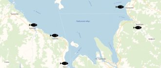
The Bratsk Reservoir is located in the Bratsk district of the Irkutsk region, on its banks there are such large cities as Svirsk, Usolye-Sibirskoye and Bratsk, after which both the hydroelectric power station and the reservoir were named. The reservoir is unique in its shape and consists of two parallel channels - the longest part of the reservoir runs along the Angara, while the second part of the reservoir is located on the Oka. The total length of the reservoir's coastline reaches 7,400 kilometers, of which 5,000 kilometers are on the Angara, and the remaining 2,400 on the Oka and Iya. It is worth noting that after the reservoir was filled, the depth of the rivers flowing into it increased significantly, thanks to which many of them became navigable.
Bratsk Reservoir Dam
(Bratskaya HPP)
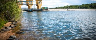
The 924 m long reservoir dam is 124.5 m high and is built of concrete. It consists of three sections: blind, stationary and drainage. On the shore, its continuation is concrete dams about half a kilometer long and earthen embankments with a total length of more than three and a half kilometers on both banks.
The dam not only serves as an obstacle to the free movement of the river. The rail tracks of the BAM and the highway are laid along its top. They connect the banks of the Angara for busy traffic flowing from the European part of the country to the Asian part.
Weather at the Bratsk Reservoir
The reservoir is located in a sharply continental climate zone, so the weather here is very capricious. In winter, frosts quickly set in on the reservoir with an average temperature of up to -25 °C; in particularly severe winters, the temperature sometimes drops to -60 °C - it is not for nothing that the territory of the reservoir is equated with the regions of the Far North. In summer, the air warms up to 24 °C, but at the beginning of June and at the end of August, light frosts are possible in the mornings - therefore, on a trip to the Bratsk Reservoir you should always take warm clothes, here they will never be superfluous.
Recreation and tourism on the Bratsk Reservoir
The name of the artificial lake appeared thanks to Bratsk, located on its shores. Both local residents and travelers from distant corners of the country come to the coast of the reservoir. They are attracted by clean air and the proximity of coniferous forests.
On hot days, Bratskoye warms up enough to swim here. In addition to coniferous trees, the shores are covered with golden sand - this is the name of one of the most popular local beaches. The water in areas far from the dam is very clean. To travel here, it is better to choose the period from mid-June to the end of August. At the beginning and end of summer, night frosts are possible. The territory of the natural object lies in a zone of sharply continental climate and is equated to the regions of the Far North. During the cold season, temperatures here drop to -25 degrees on average, which does not prevent avid fishing enthusiasts from coming to the Bratsk Reservoir in winter.
There are several recreation centers on the coast where you can rent the necessary equipment, fishing gear, and boats. For fans of “wild” recreation, there is an opportunity to find convenient sites to set up a tent camp.
These places will be interesting for tourists who are interested in history. There are several signs here reminiscent of the sites of ancient people. These include the Angarsk Village ethnographic museum, the memorial cross on Mount Monastyrka and others.
What to do in Bratsk Reservoir?
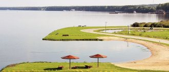
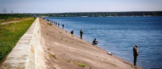
Although the reservoir is an artificial reservoir, in terms of the number of types of recreation offered, it is in no way inferior to natural ones. The water in the reservoir quickly warms up in summer to a pleasant 22–24 °C, allowing you to swim in the reservoir from the end of June. The banks of the reservoir are covered not only with taiga, but also with golden sand ideal for sunbathing. And the forest surrounding the reservoir is perfect for short walks to pick mushrooms and berries, which delight tourists already in July. Hiking near the reservoir, barbecues in the fresh air, sports games and just songs with a guitar - all this can be done on the banks of the reservoir. But the main entertainment on the shores of the Bratsk Sea was, of course, fishing - there are more than 30 species of fish in the reservoir.
Sanatoriums and recreation centers on the Bratsk Reservoir
The Bratsk Sea is considered the main vacation spot for residents of the Bratsk region and, of course, attracts many vacationers from other regions of the country to its shores. Near the reservoir there are several tourist centers and recreation centers for every taste and budget. The recreation center "Fisherman's House", for example, is ideal for a relaxing family holiday - here couples can stay in small cozy houses or settle in a tent right on the shore of the reservoir. Especially for those wishing to improve their health, the Bratskoe Vzmorye sanatorium was opened - the sanatorium is located on the shore of a reservoir among the picturesque taiga. There is a mineral spring on the territory of the sanatorium and there is everything you need for a comfortable holiday in nature. In addition, the tourist bases “Golden Sands” and “Ust-Osa” are popular among tourists, offering accommodation in both houses and tents.
Tourism on the territory of the reservoir
The Bratsk Reservoir is a very beautiful picturesque place, it’s not for nothing that many tourists come here every year. This is an excellent place for recreation and tourism. After all, the air here is truly clean, and there is a coniferous forest nearby.
In the summer, this place attracts many vacationers who like to splash around in the pond. The water here warms up quite well on hot days. And most importantly, it is very clean and transparent, so it is always pleasant to swim here.
On the shores of the reservoir there are popular beaches with golden sand, where adults can sunbathe and children can have plenty of fun.
The main holiday time here is mid-June - end of August. There are recreation centers nearby where guests can stay. In these establishments you can rent boats, as well as fishing gear and other equipment.
Subscribe to our Yandex Zen channel and give it a thumbs up!
Rest on the Bratsk Reservoir as a “savage”
Of course, staying at a tourist base is not suitable for everyone, because sometimes you want to be a “savage” - stay somewhere with a tent far from civilization and other tourists. The Bratsk Reservoir is ideal for such a holiday - you can always find a free place on its banks. The most convenient place for relaxing with a tent on the Bratsk Sea is considered to be the Golden Sands beach. The beach is covered with soft golden sand and surrounded by taiga - on the border of forest and beach and you can conveniently camp a tent while remaining at a distance from the nearby tourist base. Vacationing as a “savage” on the Bratsk Reservoir is a matter of experience; only after several trips can you find a place that suits you in everything.
Bratsk Reservoir (Bratsk Sea)
The Bratsk Reservoir acquired its modern appearance in 1967, after the completion of construction and sequential commissioning of all turbines of the Bratsk Hydroelectric Power Station.
Formed after the construction of a giant dam that blocked the Angara, the reservoir received its name from the city of Bratsk, Irkutsk region. Due to its impressive size, it is often called the Brotherly Sea. It is considered the largest in volume on the Eurasian continent and the second in the world, after the artificial Victoria Reservoir in East Africa. The Bratsk Reservoir and its banks are a unique natural area that needs protection and careful treatment. Currently, the nature of the Angara region is exploited mainly spontaneously, and the Bratsk Reservoir is becoming an increasingly popular fishing and summer vacation spot not only for residents of the Irkutsk region, but also neighboring regions. Therefore, littering the shores and poaching have become a serious problem for organized and “wild” beach holidays, as well as fishing on the Bratsk Sea.
Fishing on the Bratsk Reservoir
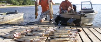
The Bratsk Reservoir is considered a paradise for fishing lovers - both beginners and experienced fishermen will find a catch here. In the reservoir, a fishing rod can catch pike, carp, crucian carp, roach and even omul. But the main catch of the reservoir is considered to be perch - the reservoir is famous for its huge perches weighing more than a kilogram. The water of the reservoir is an ideal ecological system for perches - there is plenty of food for them, which is why the size of brotherly perches impresses even experienced fishermen. It is worth noting that fishermen can count on a good catch in any season of the year - both in summer and winter the reservoir is full of fish, you just need to find out all the fishing spots in advance. Fishing tours are often sent to the Bratsk Reservoir; in addition, fishing competitions are often held here - whoever has the most catch is the winner.
How to get to the Bratsk Reservoir?
You can get from Irkutsk to the Bratsk Reservoir both by personal and public transport. You just need to follow the regional highway R-255 to Bratsk. The path to Bratsk will pass by such settlements of the Irkutsk region as Usolye-Sibirskoye, Cheremkhovo, Zima, Kuitun and Tulun. The distance from Irkutsk to Bratsk is 619 kilometers, travel time can take up to 10 hours. Shuttle buses depart regularly from the Irkutsk bus station to Bratsk. Bratsk is located on the very shore of the reservoir, so it is from this city that it will be most convenient to get to any point on the reservoir. The Golden Sands beach, for example, can be reached by minibus from Bratsk to the village of Osa, and from Osa - directly to the beach.
Main characteristics[ | ]
Satellite image.
12/19/1999 The dam at the Bratsk hydroelectric power station was built in 1961, filling of the reservoir ended in 1967. The water surface area ranges from 5426 km² to 5470 km², and the volume reaches 169 km³. The useful volume of the reservoir is 35.41 km³, the average depth is 31 m, the maximum depth is 101 m, the change in level when triggered by the pumping station is 7.08 m[2][3].
The coastline, about 7,400 km long, is heavily indented; long bays have formed at the confluence of large rivers - the Angara, Oka, and others. The width of the reservoir is up to 25 km, fluctuations in water level reach 10 m[7].